
by Denise Wauters
Many of you have been asking about the wildfire in Big Cypress National Preserve, so we’ve pulled together what we know so far and will keep this page updated as things change.
Timeline of Events
Last Update – March 13, 2026
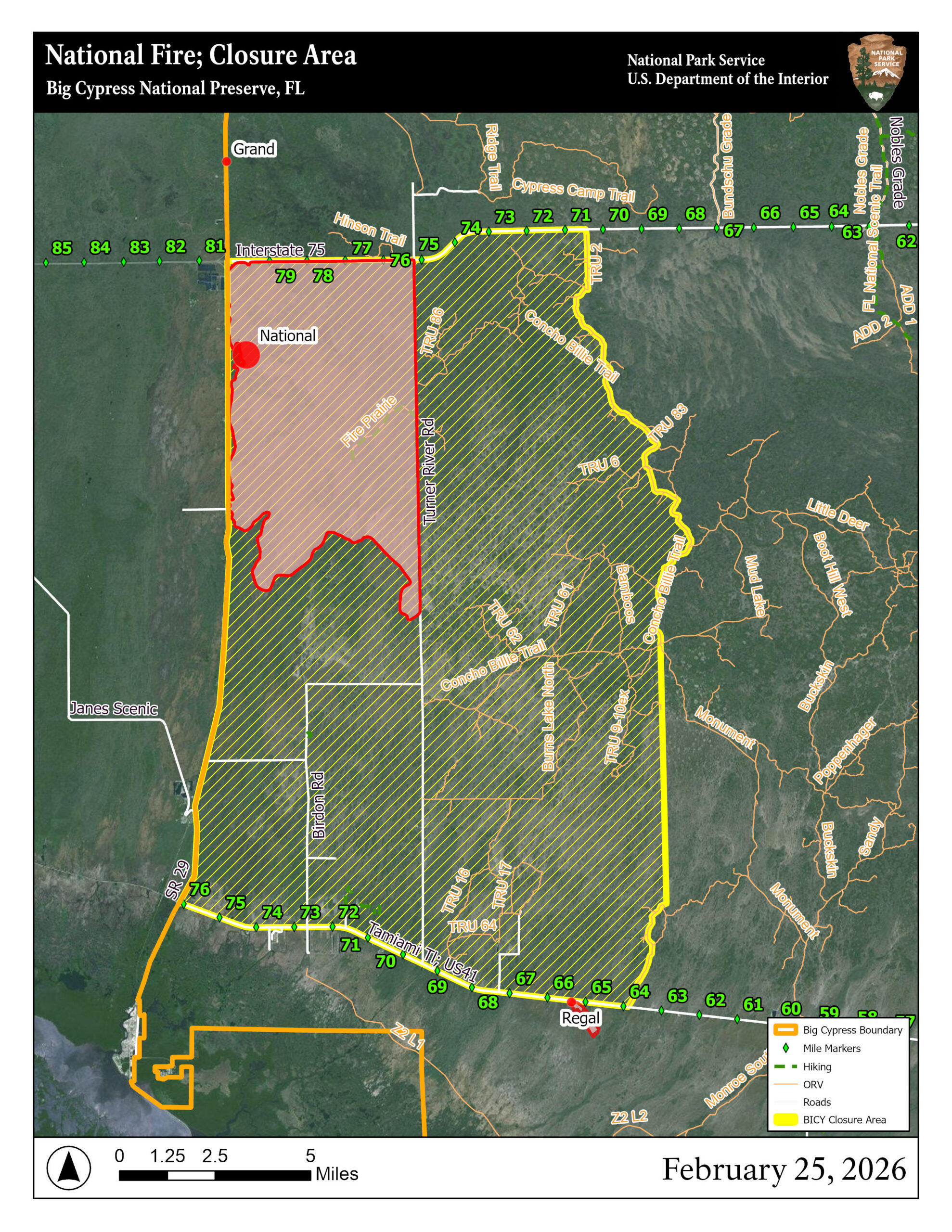
Current Fire Status
- Size: 35,334 acres
- Containment: 53%
- Start Date: February 22, 2026
- Cause: Under investigation
- Personnel: 122
- Resources Assigned: 4 engines, 2 helicopters, 2 single engine airtankers
- Managing Agency: National Park Service – Big Cypress National Preserve
Environmental conditions continue to contribute to fire behavior. A Stage 3 drought, limited rainfall, and frost-killed vegetation have left unusually dry fuels across the Big Cypress area.
February 22
Two fires were discovered within Big Cypress National Preserve. Suppression efforts began immediately.
February 23
Area closures were issued inside the preserve.
February 24–25
The fire expanded rapidly under ongoing drought conditions and frost-killed vegetation, creating heavy fuel loads across the landscape.
12:15 a.m., February 26
FDOT District 1 reported I-75 closed between Exit 80 (SR-29) and Exit 23 (US-27) due to low visibility from heavy smoke.
Later February 26
Traffic lanes reopened. The fire reached 25,780 acres and remained 0% contained. Management was transferred to the Southern Area Gray Incident Management Team.
February 27 (Evening Update)
The fire grew to 30,225 acres and remained 0% contained. Personnel increased to 154. Officials announced planned strategic firing operations along SR-29 for February 28.
February 28 (Evening Update)
The fire increased to 35,034 acres and reached 27% containment by Saturday evening. Personnel assigned increased to 197. Strategic firing operations were carried out along SR-29 between Deep Lake and Janes Scenic Drive to strengthen containment lines. SR-29 was closed between I-75 and US-41 during operations, and a voluntary evacuation of Jerome was implemented.
March 1 (Morning Update)
SR-29 is expected to reopen at 11:00 a.m. The voluntary evacuation of Jerome has been lifted. Smoke impacts remain possible overnight and early morning along SR-29 and portions of US-41. A burn ban remains in effect for Collier County.
March 1 (Noon Update)
Turner River Road (CR-839) reopened at 6:00 p.m., restoring public access to the Bear Island area and ORV trails east of the road. Fire officials emphasized that all aircraft, including drones, must avoid the fire area due to the Temporary Flight Restriction (TFR) in place.
March 1 (Evening Update)
The fire remained at 35,034 acres with containment increasing to 38 percent. No perimeter growth was reported. Firefighters continued targeted burnout operations in the southern portion of the fire and used aerial water drops to reduce residual fire intensity north of Lower Wagonwheel Road. Smoke and fog impacts were expected to remain significant overnight, particularly along SR-29 and portions of US-41 near Carnestown.
March 2 (Morning Update)
An evening thunderstorm dropped more than 0.5 inches of rain on the southern portion of the fire area. The northern portion near I-75 received little to no precipitation. Fire statistics remained unchanged from the March 1 evening update.
March 2 (Evening Update)
Containment increased to 53 percent while acreage remained at 35,034 acres. Recent precipitation helped moderate fire behavior, allowing crews to focus on reinforcing containment lines and extinguishing hot spots along the perimeter. Turner River Road remains open north of I-75. Beginning March 3 at 8:00 a.m., all trails east of Turner River Road will reopen to the public, while areas west of Turner River Road remain closed. Smoke and fog impacts are expected to continue overnight and during early morning hours along SR-29 and portions of US-41.
March 3 (Morning Update)
An evening thunderstorm on March 2 dropped more than half an inch of rain on the southern portion of the fire area. The northern portion of the fire near I-75 received little to no precipitation.
March 3 (Evening Update)
The fire increased slightly to 35,334 acres while containment remained at 53 percent. Personnel assigned decreased slightly to 207 as some equipment and resources began demobilizing from the fire area.
Fire activity remained minimal following recent rainfall. The acreage increase of roughly 300 acres was attributed to minor interior fire growth north of Birdon Road in the Deep Lake Strand area and updated mapping using a drone aircraft.
Smoke production was reduced compared to previous days, though smoke and fog impacts remain possible overnight and during early morning hours along SR-29 and portions of US-41 near Carnestown.
March 4 (Morning Update)
Firefighters continue patrolling containment lines and monitoring the fire perimeter as warmer and drier conditions return.
March 4 (Evening Update)
Personnel assigned to the fire decreased to about 180 as some resources continued to be released.
Fire activity remained minimal as warmer, drier conditions continue drying fuels within the fire perimeter. Firefighters continued patrolling containment lines, extinguishing isolated hotspots, and removing equipment that is no longer needed.
Aircraft assigned to the fire were temporarily used to assist the Florida Forest Service with another wildfire located about 12–15 miles north of the National Fire but remain available if needed.
March 5 (Morning Update)
Firefighters continued monitoring and patrolling containment lines around the National Fire as dry conditions returned to the area. Crews also used infrared-equipped drone flights overnight to identify remaining hotspots within the fire perimeter.
March 5 (Evening Update)
Fire activity remained light throughout the day. Crews continued extinguishing isolated hotspots and removing equipment that is no longer needed as portions of the fire become more secure.
Smoke impacts remain possible overnight and during early morning hours along SR-29 and nearby sections of US-41 near Carnestown, especially where low-lying fog combines with smoke.
March 6 (Morning Update)
Firefighters continue patrolling the fire perimeter and monitoring containment lines. Warmer temperatures and dry conditions are expected to continue across the area.
March 6 (Evening Update)
Firefighters continued patrolling containment lines and monitoring remaining hotspots within the fire perimeter. Crews also continued removing hoses, pumps, and other equipment that are no longer needed.
Smoke and fog impacts remain possible overnight and during early morning hours along SR-29 and portions of US-41 near Carnestown.
March 7 (Morning Update)
Crews continue monitoring the fire perimeter as dry weather persists across the area. Firefighters remain prepared to respond if fire activity increases.
March 7 (Evening Update)
Fire activity remained minimal throughout the day. Crews continued patrolling containment lines and addressing isolated hotspots within the fire perimeter.
Some firefighting resources continue to be released as portions of the fire become more secure.
March 8 (Morning Update)
Firefighters continue monitoring the fire perimeter and patrolling containment lines. Dry conditions remain across the area, though fire activity has stayed light.
This was the final morning update from the Southern Area Gray Incident Management Team. Command of the fire will transfer back to Big Cypress National Preserve fire managers and local wildland fire personnel on Monday, March 9.
March 8 (Evening Update)
Crews continued addressing isolated hotspots within the fire perimeter and removing equipment that is no longer needed as portions of the fire become more secure.
Smoke and fog impacts remain possible overnight and during early morning hours along SR-29 and portions of US-41 near Carnestown.
March 9 (Morning Update)
Firefighters continue monitoring containment lines and remaining hotspots within the fire perimeter. Dry weather conditions persist across the region.
Preserve Closures
The National Park Service has implemented a closure for portions of Big Cypress National Preserve south of I-75 and east of SR-29. Recreational use is prohibited inside the designated perimeter.
As of March 3 at 8:00 a.m., all areas east of Turner River Road (CR-839) are open to the public. Turner River Road is open north of I-75, providing access to the Bear Island area.
A March 6 amendment reopened additional areas south of Upper Wagonwheel Road, west of Turner River Road, north of US-41, and east of Birdon Road. Upper and Lower Wagonwheel Roads remain closed.
The remaining closure area includes land south of I-75, east of SR-29, north of US-41, and west of Turner River Road.
Campgrounds in the Bear Island area are available for reservations through recreation.gov.
Burns Lake Campground remains open for reservations and day use.
Visitors should check the Alerts section of the Big Cypress National Preserve website before planning trips, as closure boundaries may change.
Aircraft & Drone Restrictions
A Temporary Flight Restriction (TFR) is in effect over the fire area. The public is asked not to fly drones near the fire. Unauthorized flights can halt aerial firefighting operations and interfere with suppression efforts.
Road Conditions & Smoke
Smoke has impacted I-75 (Alligator Alley), SR-29, and US-41, with the highest risk for low visibility occurring overnight and in the early morning hours when winds calm and smoke settles. Drivers traveling through the area are advised to reduce speed, allow extra travel time, and monitor conditions through FL511 before heading out. Temporary closures remain possible if visibility drops.
When smoke and moisture settle together overnight, visibility can drop quickly, so use extra caution if you’re traveling early.
What About Local Events?
At this point, we have not been notified of any cancellations outside of the preserve’s closure zone, and events in Everglades City and nearby communities are continuing as planned.
If organizers need to share changes, please contact us at info@visitevergladescity.com, and we’ll post updates as soon as we receive them.
We’ll continue updating this page as we learn more. Check back here and follow us on Facebook. for the latest updates. on

