
by Denise Wauters
Many of you travel SR-29 and Alligator Alley regularly, so we wanted to make sure you had a place to check on the Hilux Fire burning in Big Cypress National Preserve. We’ll keep this page updated as things change.
Timeline of Events
Last Update – April 14, 2026
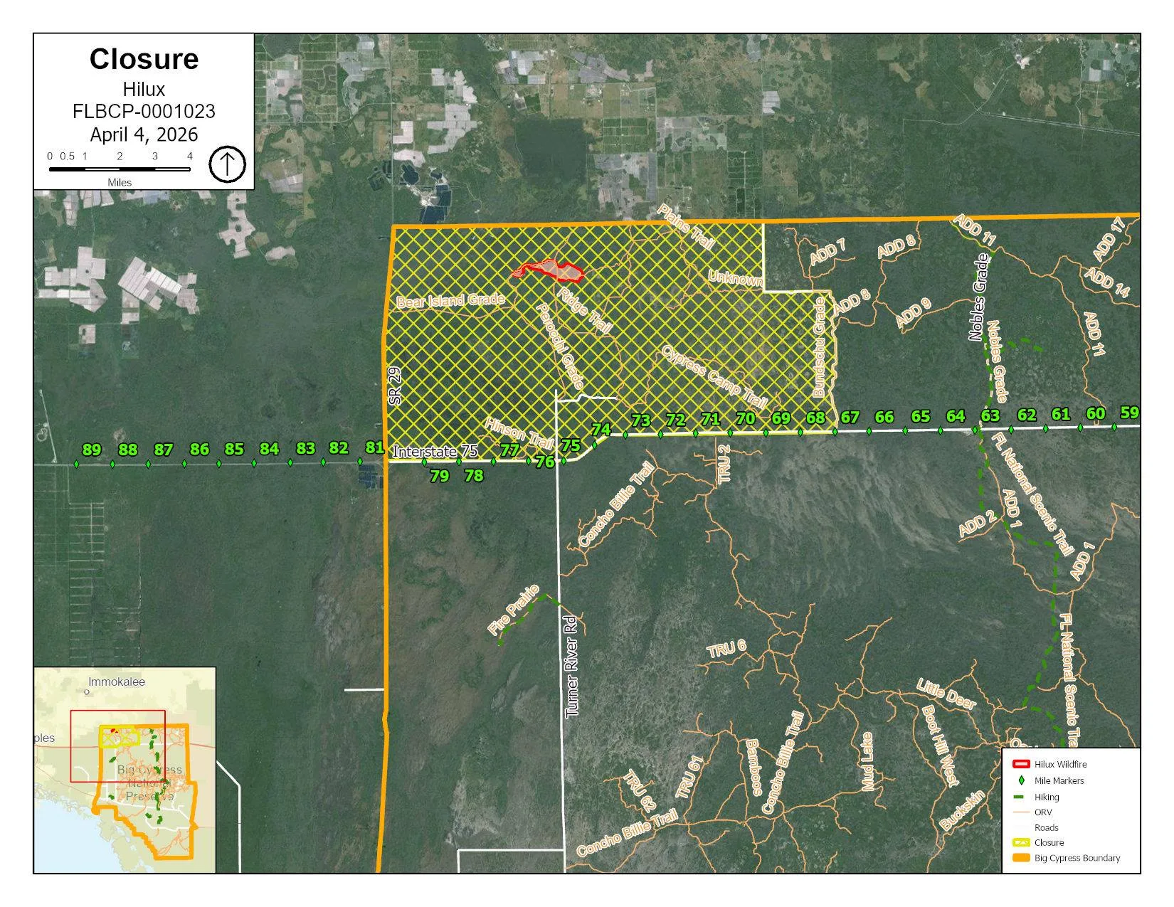
Current Fire Status
- Size: Size: 420 acres
- Containment: 65%
- Start Date: April 3, 2026
- Location: Collier County — north of I-75, east of SR-29
- Cause: Under investigation
- Personnel: 84
- Resources Assigned: 4 engines, 3 swamp buggies, 3 UTVs, 2 masticators, 2 marsh masters, 2 Type 1 helicopters, 2 Type 3 helicopters, 1 Type 2 IA crew
- Managing Agency: National Park Service – Big Cypress National Preserve
Containment reached 65% as crews continue reinforcing holding lines around the perimeter. No further smoke impacts are expected across the surrounding area, including Alligator Alcatraz.
April 3
The Hilux Fire was reported within the northwest corner of Big Cypress National Preserve, burning in pines and prairie near Bear Island Campground. The fire was estimated at 250 acres when first mapped that afternoon. Local ground and aviation crews engaged in suppression immediately, and additional resources were requested.
Smoke impacts were expected along SR-29 and on private lands and communities north of the preserve. An area closure was implemented for all land north of I-75, west of Bundschu Grade, south of the Big Cypress boundary, and east of SR-29, including Bear Island, Gator Head, and Pink Jeep campgrounds. Residents in the closure area were advised to monitor conditions and be in Ready status.
April 5
Scattered showers and overcast conditions moderated fire behavior. Most activity was along the northeastern perimeter, burning in pines and prairie. The fire reached 511 acres and remained 0% contained.
The precipitation gave ground crews the opportunity to reinforce containment lines on the northwest portion of the fire and scout additional areas for containment. Aviation resources focused on bucket drops to limit spread on the northeastern perimeter, where abundant snags made ground access difficult.
April 6
Overcast skies and high humidity continued to limit fire activity. Most heat remained in the interior of the perimeter, burning in heavy fuels. No mapping flight was completed due to weather. Acreage held at 511 acres and containment increased to 5%.
Ground crews mopped up and secured areas along the northwestern edge and identified locations for potential containment lines to the south. Crews began prep work on the southeastern portion of the fire in preparation for potential firing operations. Aviation resources were used periodically to address heat on the northeast perimeter.
April 7
Morning clouds and afternoon precipitation continued to limit fire growth. The fire remained at 511 acres with containment increasing to 10%.
Firefighters used favorable morning conditions to mop up and improve primary holding lines and scout secondary lines. Lightning exposure and difficult terrain in heavy fuels slowed progress and posed significant risk to ground responders. With the exception of UAS, aviation resources remained grounded. During a break in the weather, UAS monitored heat in areas crews could not safely access on foot.
April 8
Persistent afternoon showers over several days limited spread potential. More accurate UAS mapping reduced reported acreage from 511 to 420 acres. Containment reached 26% with 113 personnel assigned.
Firefighters patrolled and improved the northern perimeter. A masticator continued working south of the fire to create secondary holding lines. Progress remained slow due to thunderstorm activity in the area. Fire managers noted that drying conditions expected toward the weekend could increase fire behavior, and crews were preparing holding features accordingly.
April 9
Conditions remained largely unchanged, with acreage holding at 420 acres and containment at 26%. Ground and aviation resources worked in coordination, using UAS to identify previously undetected heat and guide crews to those locations for direct suppression.
Fire managers remained watchful for potential increases in fire behavior as conditions were expected to become hotter and drier heading into the weekend.
April 10
Firefighters made good progress, establishing a continuous holding line along the northern perimeter. Containment increased to 35%. The southern perimeter continued to limit access due to challenging terrain. Crews remained focused on identifying safe access points and extinguishing pockets of heat as they were located.
Conditions were expected to become increasingly hot and dry over the coming days.
April 11
A shift toward drier conditions over the past two days increased heat within the fire perimeter. The fire remained at 420 acres and 35% contained.
UAS identified multiple areas of heat along the southern perimeter. Ground crews actively constructed and reinforced holding lines in those locations. Crews on the northern perimeter continued monitoring to ensure conditions remained stable.
April 12
Despite the recent increase in heat and drying conditions, overall fire activity remained largely unchanged, with only small pockets of minimal heat detected within the perimeter. The fire remains at 420 acres and 35% contained. Personnel decreased to 93.
April 13
Conditions remained consistent as crews continued reinforcing holding lines around the perimeter. Containment increased to 65% with the fire holding at 420 acres. Personnel decreased to 84 as the response continues to wind down.
Ground crews and UAS continued working together to locate and extinguish remaining pockets of heat. Some efforts are beginning to transition from mop-up to post-fire recovery, including smoothing ruts and closing off areas not intended for public access.
Beginning April 15, management of the fire will transfer to a local Type 4 Incident organization. Barring any significant changes, this is expected to be the final update on the Hilux Fire.
Preserve Closures
A closure remains in effect for all areas north of I-75, west of Bundschu Grade, south of the Big Cypress boundary, and east of SR-29. This includes Bear Island, Gator Head, and Pink Jeep campgrounds.
Current closure boundaries are posted in the Alerts section of the Big Cypress National Preserve website at nps.gov/bicy. Boundaries may change as the fire progresses.
Aircraft & Drone Restrictions
A Temporary Flight Restriction (TFR) is in effect over the fire area. The public is asked not to fly drones near the fire. Unauthorized flights can halt aerial firefighting operations and interfere with suppression efforts.
Road Conditions & Smoke
No active road closures are in effect. If fire behavior increases, smoke may impact SR-29 and communities north of the preserve. No impacts are currently expected to Alligator Alcatraz.
If you’re heading through the area, check FL511 before you go. Overnight and early morning are the highest-risk windows for low visibility, so give yourself extra time if you’re traveling early.
Aircraft & Drone Restrictions
A Temporary Flight Restriction is in place over the Hilux Fire area. Public drone use near the fire is prohibited. Unauthorized aircraft — including recreational drones — can force aerial firefighting operations to stop, putting both firefighters and the public at greater risk.
Background
The Hilux Fire is the second significant wildfire to burn in Big Cypress National Preserve this year. It follows the National Fire, which burned more than 35,000 acres from February into early March under what the Florida Forest Service has called the worst drought conditions in 25 years. The same conditions that fueled that fire — drought, low humidity, frost-killed vegetation — are still present across the preserve, and that’s worth keeping in mind as we move deeper into spring.
Fire information is available by phone at 786-886-9342, daily from 8:30 a.m. to 8:30 p.m., or by email at 2026.hilux@firenet.gov.
You may also be interested in our Big Cypress Fire Update for Everglades Area Communities from earlier this year.
What About Local Events?
At this point, we have not been notified of any cancellations outside of the preserve’s closure zone, and events in Everglades City and nearby communities are continuing as planned.
If organizers need to share changes, please contact us at info@visitevergladescity.com, and we’ll post updates as soon as we receive them.
We’ll continue updating this page as we learn more. Check back here and follow us on Facebook. for the latest updates. on
